![]() rowmaps
rowmaps
these web pages
are being produced by
Barry Cornelius
home
maps
preferences
original data
missing data
KMLs
GPXs
CSVs
GeoJSONs
using Organic Maps
app on a phone
and getting it to
display rights of way
tweets
blog
contact
privacy
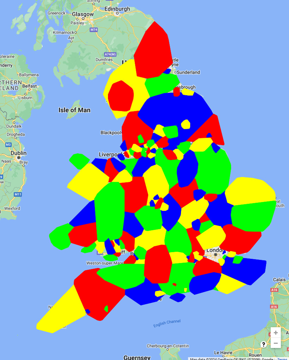
A map showing the areas where data has been released
Rights of way data for the 133 authorities in England and Wales listed below have been released under licence:
Barking and Dagenham, Barnsley, Bath and North East Somerset, Bedford, Bexley, Birmingham, Blackburn with Darwen, Blackpool, Blaenau Gwent, Bolton, Bournemouth, Christchurch and Poole, Bracknell Forest, Bradford, Brecon Beacons National Park, Brighton and Hove (City of), Bristol (City of), Bromley, Buckinghamshire, Bury, Caerphilly, Calderdale, Cambridgeshire, Cardiff, Carmarthenshire, Central Bedfordshire, Ceredigion, Cheshire East, Cheshire West and Chester, Conwy, Cornwall, Coventry, Cumbria, Denbighshire, Derbyshire, Devon, Doncaster, Dorset, Dudley, Durham, East Riding of Yorkshire, East Sussex, Essex, Flintshire, Gateshead, Gloucestershire, Gwynedd, Hampshire, Herefordshire, Hertfordshire, Hull (City of Kingston upon), Isle of Anglesey, Isle of Wight, Kent, Kirklees, Knowsley, Lake District National Park, Lancashire, Leeds, Leicester (City of), Leicestershire, Lincolnshire, Liverpool, Manchester, Medway, Merthyr Tydfil, Milton Keynes, Monmouthshire, Neath Port Talbot, Newcastle upon Tyne, Norfolk, North East Lincolnshire, North Lincolnshire, North Northamptonshire, North Somerset, North Yorkshire, Northumberland, Nottingham (City of), Nottinghamshire, Oldham, Oxfordshire, Pembrokeshire, Peterborough (City of), Plymouth (City of), Portsmouth (City of), Powys, Reading, Redcar and Cleveland, Rhondda Cynon Taff, Rochdale, Rotherham, Rutland, Salford, Sandwell, Sefton, Sheffield, Shropshire, Slough, Solihull, Somerset, South Gloucestershire, South Tyneside, Southampton (City of), St Helens, Staffordshire, Stockport, Stockton on Tees, Suffolk, Sunderland, Surrey, Swansea, Tameside, Telford and Wrekin, Thurrock, Torbay, Torfaen, Trafford, Vale of Glamorgan, Wakefield, Walsall, Warrington, Warwickshire, West Berkshire, West Northamptonshire, West Sussex, Wigan, Wiltshire, Windsor and Maidenhead, Wirral, Wokingham, Worcestershire, Wrexham, XXXXXXXX and York
These authorities
are shown coloured on this map - the colours have no significance.
Be aware that this is not a clickable map.
If you want to see a map for a particular area,
go to this web site's home page
and type a place name, postcode, grid reference, latitude,longitude or what3words into one of the boxes and then click the search button.

Credits
The above map uses
Google Maps.
A rough polygon has been superimposed on the map
for each of the authorities that has released a dataset.
To produce the polygon for an authority, I'm using the quickhull algorithm
to wrap a convex hull around the points
that form the routes of their public rights of way.
I'm using some quickhull code that was produced by
Jakob Westhoff.
